ZUKIWORLD Online – Everything Suzuki Your Complete Suzuki Automotive Resource for Editorial, Tech, Events, Adventure, Racing, and Forum
ZUKIWORLD Tackles The Final Leg Of The OBCDR.
Editor:Eric Bewley Story/Photo:Carl Beilstein Photo:S. Bewley
JOHN DAY, OR -ZUKIWORLD tackles the final leg of the Oregon Back Country Discovery route with some hardy volunteers. Awesome scenery, incredible side attractions, and great weather made this trip one to be remembered. The following is notes and stories as told by Carl.

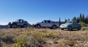
We all met up at the pre-planned supermarket in John Day. I had stretched the limits for speed when I saw I only had two hours to drive the one hundred and forty miles from Redmond to John Day. I passed an, unknown at the time, Suzuki Samurai twice on the way there having stopped for a call from nature. Even with all of this hurried activity, I arrived in John Day at 2:15 only fifteen minutes late. There was only one Samurai in the parking lot when I arrived parked alongside a nice Lexus SUV. I stopped and met Tim and his 4-year-old daughter, Cody Jean, and Rick from John Day. Tim didnt get his Samurai together in time so he was bringing the family Lexus. Lifted and locked with agressive tires it is a capable sleeper. Rick and his Samurai were not able to join the group due to more pressing issues at work and home. He had just come to the departure point to see us off and to meet Eric and the rest of the “valley people”.
The Samurai I had passed along the road arrived about ten minutes later. Stasi and his 11 year old son, Jarred, from Albany had joined the group. Another Samurai from Albany showed up shortly after, Gene and his significant other, Sharon, and their new dog, D.O.G (pronounced diogi), a one-year-old white standard size Poodle. It made a pretty full vehicle with the three and all their camping gear. They had towed their Samurai from Corvallis behind their motor home and been in town since the night before.
Now we were just waiting on the leader of the troop, Eric. A cell phone call let us know that he had to change out an alternator in Redmond. They were running a little late. The other members of the group did some last minute grocery and supply shopping as we waited. Eric and Sara arrived at 3:30 P.M. Eric was expecting another two vehicles from the Valley so we waited until 4:30 before heading out.
We headed East out highway 26 to join in the trail at the last part of Section Three. Being the outsider of the group in my Defender-at least Tim actually owned a Samurai- I got to be the sweeper, last in line. Following retired Gene in his retired Samurai, as everyone called it, I headed up the highway at 35 MPH on the uphill. There was plenty of time for sightseeing. After passing Austin Junction we turned off on a trail. My GPS said we had another half mile to go from we turned off onto the trail. Eric informed me we were taking a short cut having seen this portion of the trail the previous year. We soon hit the first trail waypoint and followed the map. At about the third waypoint I noticed that we had not taken the correct turn. Being last in line I couldnt make contact with Eric until we were a couple miles into the trail. By this time Eric had figured out the predicament and Sara had found an alternate route to get us back on track. Very cool seat of the pants orienteering by Sara. When we reached the bottom at Beaver Creek we found a young ATV rider in tears. He had run out of gas and was worried about making it back to his camp. Tim and Cody Jean loaded him up and ran him the five minutes back to his camp. Rescue number one complete.


We continued on until 7 oclock and found an old hunters camp on Trout Creek. Everyone else set about setting up tents and cooking dinner. I have installed a loft bed in the back of my D-90 so I didnt have to worry about a tent just cooking. After supper we all sat around the lantern in lieu of a campfire and listened to Genes tales of adventure in this area from his youth. He had been a fire fighter, fire lookout, and off-road motorcycle rider in the Walla Walla area when he was younger. There was great entertainment between the pokes of fun from Eric and Stasi. I retired at ten P.M. tired from the long day of driving.
Morning broke and I added more waypoints on my GPS in the warm comfort of my sleeping bag in my truck. Eric was stirring and I wish I had been watching when he got a call from nature. He was attempting to cross the creek on one of the logs that had been put across to form small pools. They were wet with due and he slipped off the deep side and took an early fully clothed bath. All I heard was a loud knock and a splash. By the time I looked up Eric was already struggling out of the waist deep water. That water must have been cold judging by how fast Eric was getting out. Later he explained that he was trying to rescue a drowning watermelon that had been left in the creek, to keep it cool, the night before by Gene.
But this encouraged me to get moving. I made egg-in-a-frames for the group. Most of them had never heard or seen this delicacy before. They are pretty tough to make. You just take a slice of bread, use a cup as a cookie cutter and make a hole in the bread. Throw the bread and hole into the fry pan with a little oil, break an egg into the hole, and turn once and, VOILA! Youve got egg-in-a-frame. This is a tasty way to start your day. I even enticed Cody Jean, who was feeling a little under the weather, to try one.
We all packed up and headed out about 9:00 A.M. with Eric and Sara leading the group. Tim and I were bringing up the rear with our enclosed cabs. At least Tims was enclosed. My D-90 is so breezy it just slowed the dust down a little. I was still getting a good coat going on everything. We reached the Highway 7 crossing and Tim asked me which way to go as I pulled up behind him. With no one waiting at the junction to show us the way I hurriedly told Tim that I thought we were heading into Sumpter. Tim thought he had seen a Samurai headed down the hill so we turned onto the highway and drove down the mountainside to Sumpter. It was a Samurai but not from our group. We cruised through Main Street, which was all decked out with vendors, keeping an eye peeled for the others. When we didnt see them we consulted the map and I saw that we were supposed to have continued onto the trail on the other side of the highway. We ran back through town and headed up Sawmill Gulch hoping to spot the others, We had just crested the top and started back tracking the trail we had missed towards Highway 7 and we met the group headed towards Sumpter.
We all cruised into Sumpter as a group. We agreed to meet at the dredge in an hour and a half. They have a huge flea market in Sumpter three times a year, Memorial Day, Fourth of July and Labor Day. With all sorts of vendors, I was especially interested in the gold panning booth. For $10 you got a bag of rocks and sand and they would teach you how to pan for gold. Stasi and Jarred had been bitten by the gold bug and I watched as they received their instruction. Looked easy enough. It took about half an hour to do half the bag of rocks. But, Stasi had some gold flakes in the bottom of his pan. I wandered around and ended up at the dredge. It is quite a large piece of machinery. The thing is huge. How they managed to drag it around in that little creek is amazing. Giant winches with three-foot windlasses. I cant imagine what kind of stuff they used for dead men to pull off of. I saw a few granite boulders with multiple holes drilled in them but nothing big enough to hold against the dredges weight. What really amazed me is that anything ¾ and larger was automatically rejected out of the dredge. They were only working for the small flakes like I had seen in Stasis pan, the size of a pencil lead or smaller. That means there could be some huge nuggets out there.


At the end of the dredge tour the Park Service had a booth set up where you could pan for gold for free. I partook of this and paid $1 for four small specks of gold out of my panning. But, now I was an experienced gold panner and I was ready to go try my luck at the real thing.


We all met up after perusing the local fare and headed back up Sawmill Gulch to rejoin the trail. Beautiful vistas ands breathtaking views abound on this trail. I just had to wait a couple minutes for the dust to clear to see them. We all stopped at Olive Creek and tried our hand at panning. Jarred said that he found three or four flakes but I never got to see them before he accidentally squirted them out of the eyedropper-like sniffer. About an hours worth of being bent over or squatting down to the water had all us old folks groaning and creaking when we finally gave up. Cody Jean hadnt gotten any perkier since breakfast so Tim decided he would take her home. This was our first mutineer.


The rest of the group headed down Olive Creek another mile admiring the nice piles of rocks left behind by another dredge. We didnt head into Granite as we were running behind schedule a little. We did stop at the Fremont Powerhouse though. It is an old brick and stone building that really looks out of place here in the wilds. It seems they had constructed a six-mile long water flume from Oliver Lake to the powerhouse. I never found out what the electricity was used for. It might have been used for the smelter of which we had seen the remains of along the road.
They have four houses here that must have been the caretakers at one time. But, now they are rented out to vacationers at $50 per night. One of these vacationers, from Boise, had neglected to stop in Baker and get fueled up before heading into the wilds. I gave him half of one of my five-gallon cans of gas to help him out. He was so grateful he tried to force me to take a twenty-dollar bill for the gas. I had to refuse.
We all loaded up and headed up to Olive Lake, which I had been told was a huge dustbowl. No dust a t all, just a really nice campground. We continued north to Desolation Butte and our first lookout. Sara and I were the only ones to muster enough energy and courage to make it to the top of the lookout. It was amazing the devastation that was caused by the pine beetles. There were great swaths of naked trees all around. I may be wrong but I dont think forest fires caused all this. Up over the ridge top and we began our descent into the valley of the North Fork of the John Day River. We turned up the river valley and passed a Road Closed at Oriental Creek sign. Miles up the road and we made camp on the banks of the river. If I had more energy in reserve I might have jumped in to wash of some of the dust. But, we all set to setting up camp. Sharon was gracious enough to fix dinner for us all, Zucchini Cakes. These were a kind of like fritters and really good. Along with the Chocolate Zucchini Cake for desert, quite the meal our meal was complete. Once again we all gathered around the lantern before retiring for the evening. Jarred and I stayed up a little later than the rest tracking big-eared bats with our flashlights.


Daybreak and Eric served peanut butter and jelly burritos for breakfast. We all got loaded up and decided we would investigate the road closure before resorting to the longer route around. As we drove up the river canyon Eric spotted salmon spawning in the river. I guess they werent really spawning but had picked out their nesting spots and were driving off intruders. We watched as these three-foot long fish chased away intruders in the shallow waters, sending rooster tails of water into the air behind them. We stopped at three or four places along the river to watch. They werent bright and shiny fish but it was still a captivating show.


We reached Oriental Creek and campground and found that there was no road closure. We took the trail right up the spine of the ridge to the top. There were more awesome vistas of great valets. Two thousand foot deep troughs we were climbing out of. Quite a bit of fire and beetle damage made it easy to see all the way to the bottom. We hit the Ukiah highway for about four miles and then it was back onto the dusty path. We climbed right up to Tower Mountain and the lookout there. Desolation Butte just looks like a little hummock from here. Its about 25 miles south of here. The tower is just barely visible to the naked eye. This is an old style metal lookout made by Aeromotor of Chicago. It must be lots of fun during a lightning storm. Once again, Sara and I are the first to make the ascent to the top. There is a four-person limit in this tower and at Desolation Butte. That means only three visitors and the ranger. This lookout is so small that I think four people would be like sardines in a can. It looks out over a five hundred foot cliff to the east. The ranger pointed out a recent 600-acre lightning started burn-two weeks old- that was easily visible from up here. They will still be working on the hotspots probably until the fall rains.
We stopped for lunch before moving on and while waiting for Gene to come down from the tower. It seems that he had worked with some of the same people as the ranger when he was younger and did some catching up with the ranger and his wife.


We continued our northward trek and the next point of interest was the grass savannahs of Camas Creek. These look like something out of Africa. The only difference is the pine trees. With the four vehicles in a row going down the dusty road I could easily envision us on some great safari. We continued north and the trail just got dustier. We were seeing more hunter campsites also.
While waiting on Who-who had been taking turns driving with his Dad-I had to let a large Ford van get in between us and Gene and Eric. Great! another dust master to follow. It was here that the map leads us astray for a bit. It showed us continuing northwest at the top of one page and due north on the continuation on the next. It took a little bit to figure out but we were soon back on track. Eric missed a turn shortly after this and the road we were on petered out in a large meadow. We could tell by the GPS that we were very close to being on the trail. So, we headed north across the meadow through fallen logs and found the trail again. This is where it really got dusty. A foot of fine talcum powder-like dust. Eric headed with Stasi waiting about five minutes for the dust to clear before heading out into the dustbowl himself. As I waited for the dust to settle Gene was coming out of the meadow. I thought he had seen me or at least would have seen the dust cloud as I took off. I tried to search out the high portions of the track thinking the shallower dust might not leave such a big cloud. It soon turned into hard-packed rock as I descended down to Waucup Meadow. Stasi took off up to Wildhorse Spring as soon as I arrived. I waited, and waited, and waited for Gene and Sharon to come down the hill. Twenty minutes had passed when I decided I better go looking. I called on my CB all the way up. Barreling through the dustbowl again I found Gene out walking D.O.G (pronounced diogi) and Sharon nowhere in sight. Gene said that he had not heard Erics instructions to go right when you hit the road and hadnt seen me take off or the cloud of dust I was sure I left behind. He headed back up the road to retrieve Sharon and I got started back down the hill. I met Eric and Stasi at the top of the long downhill. They had become concerned when we hadnt shown up at the next waypoint. Good people to have along on a trip.


We continued along McCoy Creek canyon headed east before turning north at MacIntyre Creek. Seeing more of civilization as we went we ended up crossing the railroad tracks at Kamela on I-84. I had been telling Eric all day that when we reached I-84 I would need to get fuel. I had planned on going into Meacham for gas. Eric said that we would head out towards Mt. Emily, find a camp and then I could go get fuel. About ten miles up towards Mt. Emily my fuel concerns were getting serious. Because of the dust build up on my air filter I was not getting my typical mileage. I was getting concerned with that I might not even make it back to the freeway. Eric decided that we should stop and discuss the situation. Stasi and Gene were concerned that our elevation was continuing to get higher and the temperature was a little chilly for sleeping in a tent. Sharon thought that a motel in La Grande sounded good. Hot shower, warm bed and all. I was determined that I was going back for fuel. Eric decided that they would push on forward to Elgin for the night and continue the trek on Monday and finish on Tuesday. That was where I hit a stop sign. I couldnt finish on Tuesday. I had important issues at work that would not allow me that sort of levity. So, I decided that I would end my participation in the adventure at this point and head for the barn. The second mutineer.
Eric and the group went north and I headed south to I-84. I headed towards Pendleton knowing there is a six mile long downhill on Cabbage Hill that would allow me to coast into a gas station. I was right. I coasted into the Umatilla Indian Reservation gas station on fumes.
SO, that’s where Carl left us and thus his part of the story ends.. The rest of the group was a little surprized that Carl would leave because he is definitly an adventure enthusiast but sometimes you just run out of time. Now, we were down to three vehicles Stasi, Gene, and me.
It was at this time that the sun was starting to set. Gene and Sharon were think about a nice shower and a bed instead of camping in the chilly night air. So they also dropped out and headed for La Grande.
It is down to two rigs! Four hardy souls trekking along the lonely trail as the sun is setting, gas is running out, and there is no camping in sight.

Before we make it to camp, I have to stop and use some of my Gerry can to put some more go juice in the Samurai. Stasi is on fumes also so I left a gallon or so in the can just in case. We finally did make camp at Target Meadows, an old army target range, around 10 or so at night. It wasn’t great pitching a tent and cooking in the dark but sometimes these adventures are a little difficult. That’s what give them character! We went to sleep knowing that tomorrow was going to be a long day.
Monday morning, I had set the very ambitious goal to finish the trail and make it all the way back home so that Sara and I could make it to work on Tuesday. This was going to be very challenging because not only did we have the trail to finish we had about 500 miles of highway to get back home after that. We had better get started.

Eventhough the scenery was excellent along these last few miles of the trail the trail was not that enjoyable. It is used heavily and is really a gravel road from I-84 to the Washington boarder. There is not to much to do other than look around which is OK. We finally made the Washington boarder and Sara and I felt a serious amount of pride in our accomplishment of riding the whole OBCDR in a Samurai.
I was very greatful that Stasi and Jarred continued on with us for their company is always welcomed. Next was on to Walla-Walla to fuel and air up. After which we hopped on the highway and headed home. There are some really cool towns and rivers we crossed as we took only secondary and tertiary roads back home. This is always the way to travel if you can. There is so much out there to see once you get off of the freeway it is amazing. Stasi and Jarred pealed off for another night of camping somewhere in the middle of Oregon while we pressed on to make it home at about eleven Monday night exhausted from the days miles.