Direct Coordinates
By Junior
ZUKIWORLD Reviews Magellan’s New Map 330 GPS
Ever pull over to read a worn-out map that takes up nearly the entire cab of the car, or have someone give you chicken scratch notes to a far away spot spelling out turn left at forest service road then look for the fallen tree ? Only to find yourself once again driving around aimlessly enjoying the scenery but never reaching the intended destination. GPS (Global Positioning System) just might be for you. The US Government over the past 10 years has relaxed its regulations on the use of GPS, giving the public access to the many satellites orbiting the earths atmosphere.

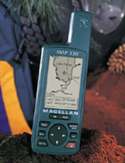
We at ZUKIWORLD have selected the Magellan Map 330 GPS for our tests and long-term trail reporting tool. Over the next 10 months well put the Map 330 through the paces both on and off-road. Well provide tips and tricks, pros and cons, and over all reporting on the quality of this fully self-contained GPS.
Mounted to the dash of our F-250 Super Duty while traveling to Californias famous Rubicon trail we noted the unobtrusive effect on the drivers ability to safely see the road while glancing every now and then to check data such as distance to destination and future scheduled stops. Speaking of stops, we made an unscheduled stop in an unfamiliar city along the route. Without knowing the cities streets we paid close attention to our GPS where we found information like freeway entrance and dead-end roads. (dead-ends reek havoc on trucks pulling car-trailers)
![]()
Nows our chance to take a way point of this roadside fuel stop and add it to our route. The Map 330 allows the user to customize a route at anytime. Within the system menu the user can select from an assortment of icons marking the weigh point. For example, this stop we found affordable fuel, easy access to the freeway, and good food. Naturally we assigned corresponding icons representing a gas pump and the fork and knife icon. The user also has the ability to name these icons for this particular stop on the route. We elected to name the fuel stop by its brand and the food by simply calling it Good. And if that werent enough, the Map 330 has another feature one might not expect, thats the ability to place a message on a waypoint. In our case we chose to put the cost per gallon for diesel, and the total food bill. Not only will this aid in selecting whether or not to stop here on the return trip or future trips, but we will also extract this data once we are home for appropriate expensing.
For the techno interested in the exact specifications; the Magellan Map 330s receiver uses 12 parallel-channel technology and tracks up to 12 satellites to compute and update information with its quadrifilar antenna. Satellite acquisition times are 15 seconds warm and 1 minute cold, while the update rate is 1 second continuous. Accuracy is within 49 feet, however we can attest we found it to be far more accurate than that. The GPS weighs a mere 7 ounces and uses 2 AA alkaline batteries or 9-35 VDC with power cable. We found a consistent battery life of around 10 hours of use.
Accessories for the Map 330 are endless. From swivel mounting brackets to leather cases. We opted for the vehicle mounting bracket for full hands-free operation and the PC cable/cigarette lighter adapter combo. The cables simply attach to the back of the mounting bracket where the GPS can be removed for portable use and replaced for in vehicle use.
Were excited about our on-going tests of the Magellan Map 330, and will keep you up to date in our future trip reports where well be using the GPS and publishing direct coordinates to the places we travel.
This highly complex but simple system can not only pin point the exact spot of an incredible waterfall, but also put you right on top of a downtown street address in any given city in the world. Magellan is just one of the many globally advanced companies providing the private sector with hand-held GPS systems packed with sophisticated technology. Were confident you too will find many uses for the Magellan Map 330 GPS, no go have fun.
 ZUKIWORLD Online – Everything Suzuki Your Complete Suzuki Automotive Resource for Editorial, Tech, Events, Adventure, Racing, and Forum

